The gable of the Iamgold Office in Paramaribo, Suriname is adorned with a profile portrait of Mansa Musa (1312-1337), the ninth Mansa (king) of the Mali Empire (6th to 13th century). “In 1324 Mansa Musa went to the hajj in Mecca, traveling with an enormous entourage and a vast supply of gold. While in route, he spent time in Cairo, where his lavish gift-giving is said to have noticeably affected the value of gold in Egypt and garnered the attention of the wider Muslim world.”[i] When asked who he was, Mansa Musu was reported to have said “I am gold,” and this became the name of the mid-tier gold mining corporation established in Toronto in 1990. In 2006 Iamgold acquired Quebec-based Cambior Inc., and became the owner of Rosebel Gold Mine, a property in the Brokopondo District of Suriname.
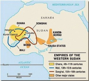
The gold mining history of West Africa was written by three empires, Ghana, Mali and Songhai.
“The rise of the Soninke empire of Ghana appears to be related to the beginnings of the trans-Saharan gold trade in the fifth century.”[ii] “This West African empire based in the modern-day southeast of Mauritania and western Mali that existed from c. 300 until c. 1100. The Empire was founded by the Soninke people, and was based in the capital city of Koumbi Saleh. Galam, Bambouk and Bouré were the three main gold mines exploited by the Ghana Empire.”[iii] “Around 750 a Berber merchant reported that Ghana had established a complete monopoly of the gold trade with the Arabs.”[iv] The rise of the Soninke empire of Ghana appears to be related to the beginnings of the trans-Saharan gold trade in the fifth century, though salt also became an important commodity.
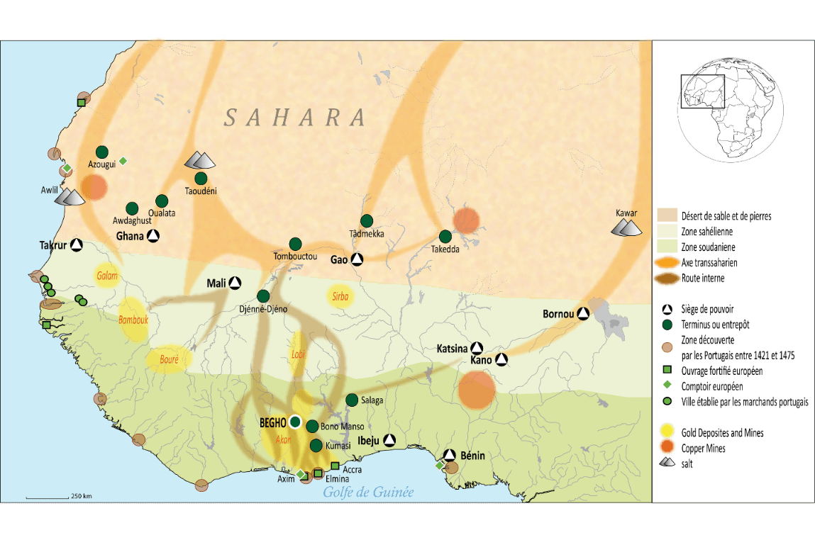
“From the 1200 to 1600 AD West Africa was home to the great Mali Empire. Established by King Sundiata Keita, the Empire united several smaller, Malinké Kingdoms near the Upper Niger River. Mansa Musa was the ninth King of this empire. The rise of Djenne and Timbuctu as influential trading centers corresponds well with the eastward expansion of the Mali empire in the mid-1200s and probably coincides with the increasing importance of the Akan goldfields.”[v] Certainly, by about 1400 the Akan city of Begho (see map below) located on the northern fringe of the heavily forested areas is mentioned as an important gold trading center through which much of the gold is channeled on its way to the major cities along the Niger River far to the north. Mali probably did not directly control the southern gold-bearing regions but, rather, extracted from them the precious metal as tribute.
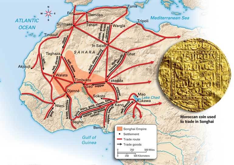
“The Songhai empire, also spelled Songhay, also was a great trading state of West Africa (c. 1460 – c. 1591 CE), centered on the middle reaches of the Niger River in what is now central Mali and eventually extending west to the Atlantic coast and east into Niger and Nigeria. The Songhai, continuing the tried-and-tested wealth accumulation method of trading sub-Saharan commodities and extracting tribute from conquered tribes.”[vi]The Songhay empire was also founded on these wealthy trading centers which remained influential until at least the 1500s, when European traders began to establish more direct contact with gold traders along the Atlantic coast (see the trade route map of the Songhai Empire below).
“By contrast to the situation in Europe, many states in West Africa in the 15th century were in a process of expansion and growth. Mossi was established in the 15th century in Burkina Faso, Kano became a major power, and Songhay rose to usurp the power of the Mali Empire. Much of this growth came with increased gold production in the Akan states of the Gold Coast. So much gold was produced that the trans-Saharan trade did not bring enough goods to exchange at Kano, and many gold traders left empty-handed”[vii] [this is according to the early 16th-century Muslim traveler from southern Spain known generally as Leo Africanus].
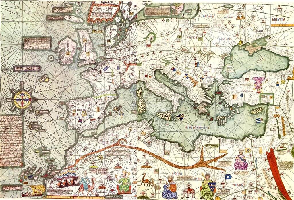
“The Portuguese were aware of this growth through a number of channels. The Catalan Atlas of c.1375 was a map drawn by a Majorcan Jew called Abraham Cresques, which showed the power of Mali and its gold production in detail. However, the caravan trade of gold into the Mediterranean and Europe, which started during the Ghana Empire, would not last.”[viii] The image of Mansu Musa, with a gold nugget in his hand, is at the bottom of the map.
“French sailors from Dieppe are said to have reached the Gold Coast as early as in 1364 and had built a stronghold at Elmina in 1413. But only the arrival of the Portuguese on the Gold Coast in 1471 is historically documented. They started trade in gold dust at the mouth of the river Pra at Shama after having passed by ship Cape Three Points and Cape Coast. This gold trade was monopolized after a short time by the Portuguese Court and led in 1482 to the construction of the castle Sao Jorge da Mina (later Elmina) with the aim to secure the gold trade mainly against other European competitors.”[ix] However, in the 15th to 17th Century the activities of these European forces were restricted to the coastal areas alone.
“Between the 10th and 12th centuries AD the ethnic Akan people migrated from the Northwest of the area of today`s Mali into the forest belt of Southern Ghana (the Central Region) and established several Akan states. These migrants split up into several tribes and assimilated or drove away the inhabitants they met with in the land. They founded and developed the states of Akwamu, Akim, Fante, Denkyera and Asante. These state forming processes were accompanied by various conflicts and wars and the resulting prisoners of war became a main source of supply for the emerging slave trade at the coast and led in turn to the acquisition of iron weapons, especially rifles and black powder from the Europeans. Eventually the separate Asante chiefdoms were united by Osei Tutu in the 1670s and in 1696 he took the title of Asantehene (king) and founded the Asante empire. Again, gold played an important role in the life and trade of the Asante.”[x]
“The Asante nation rapidly became more powerful by forming alliances with neighboring peoples, leading to the formation of the Ashanti Union around 1700. Asei Tutu built a capital, Kumasi, and created the legend of the Golden Stool to legitimize his rule. The throne became the symbol of Ashanti authority. By 1750 the Asante Empire was the largest and most powerful state in the region. The empire’s wealth and prosperity was based on mining and trading in gold and trading in slaves. The Asante also became famous for woodcarvings, furniture, and their brightly coloured woven cloth, called ‘kente’. The kingdom continued to expand until, under King Osei Bonsu (1801-1824), Asante territory covered nearly all of present-day Ghana.”[xi]
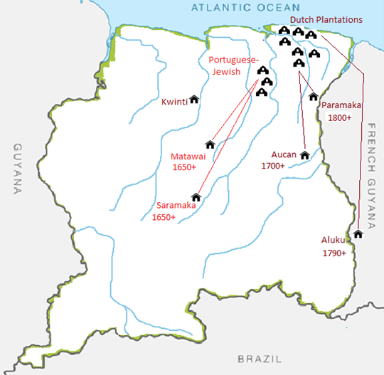
After 1700 this history of gold expertise found its way into Suriname by way off the slave trade. The warriors of the expanding Ashanti Empire (1701-1901) captured men and women in the gold rich territories surrounding Kumasi, the Asante capital. In 1722-23 the Asante even invaded Bhego, the gold trading center of North Ghana. These captives were traded with the Dutch for weapons, ammunition, textiles and other goods, and were transported to Suriname to work on the plantations. Through rebellions and escape thousands of African fled into the dense rainforest and eventually established six independent Maroon (escaped slave) communities. As an astute Africanist might have expected, the settlements of the first Maroons were all located in highly auriferous areas: Sentéa Creek (Saramaka), Mama Ndjuka (Aucan) and Paamaka (Kiiki Mofo, Nassau Mountain).
Suriname in the colonial trade economy
Suriname was known as Willoughbyland and was governed by the British from 1651 to 1667. In 1667 the Dutch took over and controlled Suriname until independence in 1975, with the exception of a British intermezzo from 1799 to 1816.
Prior to 1613, when the first Dutch colonizers landed in Surname, the coastal area of the country was inhabited and controlled by the Caribs (Kaliña) and Arowhak (Lokono). Two other nations were reported, the Sapoyers and Paracotten, but they either left or perished after the arrival of the Europeans. The Sapoyers were spread out from the Corantyne to the Marowijne River, while the Paracotten lived along the north-east coast of Suriname. The colonial prelude lasted from 1613 to 1650, and during this period Dutch, French and British traders and planters tried to establish permanent settlements, but failed due to the armed interventions of the Indigenous nations who resisted the incursions of the Europeans who tried to dominate them.[xii]
Around 1651 Lord Francis Willoughby sent a scout to survey the coast and the mouth of the Suriname River. The reports were encouraging and in 1652 Willoughby set sail to Suriname and managed to establish the first permanent settlement in the country. He took along a delegation of experienced Portuguese-Jewish planters, who travelled up the Suriname River and began to clear plantations on the high savanna ground. The English planters also selected high ground along the Para and Commewinne Rivers. Willoughby also brought two Indigenous chiefs with him to Barbados reached an agreement with them, allowing English and Jewish planters to establish plantations settlements in Willoughbyland. The British planters took Indigenous slaves, which was not without risk. The English constructed a walled fort on the location of what is now Paramaribo, from compacted shell sand stones, and this seems to have protected them from attacks by Indigenous warriors.[xiii]
Soon after the British arrived Africans were transported form the Slave Coast (Togo, Benin and Nigeria today) and from the Loango Coast between Cape Lopez and the Zaire River, to work on the plantations. As soon as Africans arrived on the plantations and were put to work, the courageous among them began to escape into the dense rainforest and formed groups. Often in partnership with the Indigenous, the escaped slaves began to raid the plantations to secure weapons, ammunitions, metal implements and to obtain women to develop their communities. By the time the Dutch took over Suriname in 1667 about one hundred plantations were operational. During the Dutch takeover there was a period of chaos brought on by English planters who destroyed their plantation and left with equipment, sugar and slaves for Barbados and other destinations. Slaves took advantage of the frenzied situation to escape and join existing groups of Maroons. The history of Willoughbyland was over.
During this period two Creole languages had developed in the colony. The African on the Portuguese Jewish plantations developed a Portuguese-African Creole which became known as Saamaka and Matawai. When the Saamaka and Matawai Maroons escaped into the rainforest they spoke “Jew Tongo” which materialized on the Portuguese-Jewish plantations, a Creole language with mainly an African and Portuguese vocabulary. During this same period an English-African Creole developed on the British plantations, and became known was Sranan Tongo. The Aucan Maroons, and later the Paamaka and Aluku Maroons, would also use and develop this Creole.
At the end of the 18th century the Dutch has a falling out with the King of Benin on the Slave Coast. They refocused their trading activities to the Gold Coast. The Dutch has already established or conquered several forts on the Gold Coast, and after 1700 their trade with the expanding Asante Empire intensified significantly. This was also onset of the second period in the development of the plantation economy of Suriname. Between 1700 and 1770 the number of plantations increased from 100 to over 500. The number of slaves entering Suriname also increased accordingly, and the number of slaves which escaped from the plantations also increased. By far the largest group was speakers of Twi language in Ghana and the eastern part of the Ivory Coast. Around this time the Dutch used irrigation technology to manage the tidal fluctuation on the low-lying coastal estates, and this required considerable slave labor to dig the canals and build the dikes and sluices. Most of these newer plantations were established in the lower lying coastal areas along the Lower-Suriname, Commewijne and Cottica Rivers.
As the number of plantations increased, rebellion and escape turned into ongoing Maroon wars. One of the most significant uprisings in Suriname was the Tempati Rebellion. This rebellion later grew into one of the most powerful maroon groups, the Ndyuka. “One day in 1757, the plantation owner of La Paix, a certain Mr. Martin, made a decision to send some of his timber slaves to go work one of his sugar plantations. The slaves refused to exchange the better life on a timber plantation for the toil on a sugar plantation. This decision set off a series of events that led to the uprising, consisting of several plantations in the Tempati region, namely: Plantation Bleyenburg, Plantation Maagdenburg, Plantation L’Hermitage, Plantation Beerenburg & Plantation La Paix.”[xiv]
The uprising involved 300 escaped slaves, who were joined several hundred Aucan (Ndjuka) Maroons already living in the area. The fear of a massive revolt in the plantation colony became widespread.
In 1760 the colonials were forced to sign a peace treaty with the Ndyuka, which made them in essence a free state within a state. In 1762 a treaty was signed with the Saamaka Maroon, followed by a treaty in 1768 with the Matawai Maroons, who had spit off from the Saamaka. The provisions of the treaties allowed the Maroon to settled and subsist in the interior, south of the plantation belt, as long as they refrained from attacking plantations. In exchange, the colonial government provided these liberated societies with weapons, ammunition, metal implements and other supplies. Because the Maroon societies signed treaties which forbade them to take in newly escaped slaves, three new Maroon groups emerged: the Paamaka, Aluku (Boni) and the Kwinti.
The Origin of African Surinamers
In his thesis on the “Dutch Participation of the African Slave Trade” (1970), Johannes Postma said that it was not his intention to record and trace the ethnic origins of the Africans who were transported to the Dutch colonies in the Caribbean. He said that the primary objective was to determine the quantitative share of the Dutch participation in the Atlantic Slave Trade.
Our objective, however, is to go beyond that intention and set out to quantitatively assess where the ancestors of Surinamers of African descent originated in West Africa and along the Loango coastal region between Cape Lopez and the Zaire River. We can use the data from Postma to make this quantitative assessment, however, we need to retabulate the data using other categories. Traditionally slave census data has been compiled on the basis of navigational landmarks demarcating coastal areas such as the Grain Coast, Windward Coast, Gold Coast, the Slave Coast and the Loango Coast north of the Zaire River. For example, the Gold Coast is between Cape Three Points and Cape Sint Paul, coastal navigational landmarks which most African mainland residents in the 18th century would not be familiar with.
We suggest, however, to instead use the “Cultural Provinces” developed by Peter Murdock in in 1959 publication “Africa: Its Peoples and their Culture history.”[xv] In developing the map, he grouped some 800 kin-ordered societies into 100 cultural provinces, which takes into account geography, language, economy, society (kinship), government and history. We then started retabulating the detailed shipping data compiled by Postma, while using the cultural provinces developed by Murdock to regroup the data. The results were extremely impressive and generated a completely different outcome.
The table with the “African Proveniences of the Dutch Slaves” listed in the “Historical and Bibliographical Introduction” by Richard price (1976) provides the following breakdown in percentages, which is often used to deny the importance of Africa influences in Suriname.[xvi]
1640-1700
1701-1725
1726-1735
1736-1795
Windward Coast
–
–
4%
49%
Gold Coast
2%
17%
29%
26%
Slave Coast
64%
50%
33%
1%
Loango/Angola
34%
33%
33%
24%
Price concluded that this information reveals that the slave population was considerably more heterogeneous than previously assumed by other scholars, who supposed a significant influence from the Gold Coast region (Akan, Twi speaking Africans in Melville Herskovits, 1934).
Our new results, however, paint a completely different picture. To start off, we used absolute numbers instead of percentages, for 50% of 10.000 is less than 25% of 100.000. The table below provides an overview of the results of the re-tabulation based on the Cultural Provinces of Murdock.[xvii]
SOCIO-CULTURAL ORIGINS OF THE SURINAMERS OF AFRICAN DESCENT
Period
Twi-Akan
NW-Bantu
Kru-Mande
Yoruba-Nupe
Sub-Total
1650-1700
500
5500
–
10000
16000
1700-1730
13000
14500
4000
15000
46500
1730-1780
87500
42000
43500
2000
175000
1780-1800
25000
12000
12500
500
50000
Sub-total
126000
74000
60000
27500
287500
Percentages
44%
26%
21%
10%
After 1800
17000
11000
7000
1000
36000
(49%)
(29%)
(23%)
(0.3%)
Total
(143000)
(85000)
(67000)
(28500)
323500
If we assume that after 1800 very few slaves were boarded in the Yoruba-Nupe culture provinces, and we proportionately distribute the rest across the other three culture areas, we would get the provisional results listed at the bottom of the table above. This breakdown is not nearly as heterogeneous as Price suggested, the Twi-Akan group of Africans is clearly dominant.[xviii]
All six Maroon societies that eventually formed in the interior of Suriname were matrilineal, essentially because the largest number of Africans who came to Suriname originated in matrilineal belt (see map to the left), especially on the Gold Coast (Akan, Twi speakers) and Ivory Coast (Baule), as well as on the Loango region between the Zaire River and Cape Lopez in Gabon (North Wester Bantu culture area). Thus, most of the African nations where the Maroon originated from were also matrilineal. Matrilineality is the tracing of kinship through the female line. It may also correlate with a social system in which each person is identified with their matriline – their mother’s lineage – which involves the inheritance and use of clan and lineage property, and the acquisition of political titles in the community as well as the higher-ranking political functions in Maroon society.[i]
Governor Cornelis van Aerssen van Sommelsdijck sent out an exploration expedition in 1687 and 1688, which, however, yielded no results. However, in 1716 indications of gold were found at the Blauwe Berg on the Suriname River (today Berg en Dal), and in 1718 the government funded the first gold mine in Suriname. This activity stopped after a few years because the costs were higher than the revenues. From 1726 to 1741 the second government gold mine was developed along the Suriname River at the Van den Bemptenberg, diagonally across the river from the Victoria Palm Oil Plantation. In 1736 a half kilo of gold dust was exported to the Netherlands, probably originating from this mine. Between 1742 and 1745 the third gold mine was established, this time a private enterprise ‘The Patented Suriname Mineral Company.’ The mine was probably further upriver at the Maroon village known today as “Compagnie Kreek.” The mountain behind the village contains a rich gold deposit. In 1745 a tunnel collapsed and the venture was abandoned. Some Maroons and Creoles went on to search for gold on their own.[xx]
Perhaps this explains why in 1741 the West Indies Company, the owner of Suriname, published a law stipulating that it was illegal for slaves to exchange or sell gold, minted or un-minted, unless they had a permission letter from their owner. We know that in 1741 gold was being mined by the private enterprise, but how did “un-minted” gold find its way into the streets of Paramaribo. The Maroons or Creoles could have been a likely source of this gold.[xxi]
Again, in 1761 the law was published indicating that it was illegal for slaves to exchange or sell gold, minted or un-minted, unless they had a permission letter from their owner. This law was published again in 1763, stipulating that it was illegal to buy gold, silver or jewelry from slaves, and this warning was intended mainly for jewelers and goldsmiths. In 1777 a law published by the West Indian Company indicated that “slaves, mulattos, Indians or negroes were not permitted to wear gold jewelry, with the exception of modest gold earrings, necklaces or bracelets with fasteners.”
We noted above that as an astute Africanist might have expected, the settlements of the first Maroons were all located in highly auriferous areas: Sentéa Creek (Saramaka), Mama Ndjuka (Aucan) and Paamaka (Kiiki Mofo, Nassau Mountain). It is likely that the Maroons managed to pass on gold to slaves in Paramaribo for sale, as the dates of the publication of the gold prohibitions coincided with significant historical events in gold mining and the peace treaties.
The first law prohibiting the sale of gold by slaves was published in 1741 and coincided with the second government mine operation from 1726 to 1741. Oddly enough the law was published again in 1761, a year after the peace treaty was signed with the Aucan Maroons. Under the treaty the pacified Maroons were permitted to travel to town with a permit letter from the colonial Postholder, which was station in the Aucan, Saamaka and Matawai territories. Did the Maroons take along gold with them to purchase goods while they were visiting Paramaribo? Strangely enough, the law was published again in 1763, a year after the treaty was signed with the Saamaka. Did the Dutch colonial government notice an increase in the sale of gold just after the first two treaties were signed? The timing of the publication of these laws seems to suggest that this was the case.
Finally, we can’t help noting that prior to the arrival of Twi speaking Akan Africans in Suriname, with extensive experience on gold mining, efforts to find gold in the interior of Suriname failed. As soon as the influx of slaves from the “Gold Coast” increased significantly, gold was found in Suriname. What a coincidence. This is not surprising; geologists know that the mineralization patters on the Gold Coast and in the interior of Suriname have a shared history. When the first gold deposits were formed in Suriname some two billion years ago, Africa and South America shared the same continent – Atlantica.[i]
While visiting Kumasi and the nearby Obuasi gold mine, I was struck by the striking similarity of the landscapes.[i] The lateritic and saprolite soils in the Kumasi region reminded me of the natural environment and earth in Brokopondo District in Suriname, where extensive gold mining takes place.
The Twi-speaking Akan Africans escaping into the rainforest must have recognized these shared natural features, and their auriferous initial settlements suggest they did. As noted above, the first permanent settlements of the Saamaka, Aucan and Paamaka were all situated in areas with gold mineralization. Mama Ndjuka, a tributary of the Marowijne, river just south of the Tapanahony river, the site where Aucan nation initially settled, hosts rich gold deposits.
The ”re-discovery” of gold
Gold was formally discovered in French Guiana in 1854 on the Approuague River by Paoline, a Brazilian metis from Ouro Prêto.[xxiv] A gold rush ensued, and the Suriname Maroons quickly became involved in the French gold mining trade, as providers of river transport over the treacherous cascades. The Boni transported miners and supplies for the placers of the Upper Maroni and Inini rivers, the Djuka on the Surinamese shore of Marowijne, and the Saramaca on other rivers of French Guiana (Mana, Approuague, Sinnamary, Oyapock). Twenty years later the gold discoveries in French Guiana would trigger the Suriname government to outfit an expedition to the Marowijne River.
The first gold rush (1875-1930)
In 1874 an expedition was outfitted to explore for gold between the Arawarra (Pakira Creek today) and the Gran Creek and used the colonial steamship Paramaribo as base. Some 17 Maroon and Indigenous persons joined the expedition as carriers and rowers. Indications of gold were found and in the period 1876 to 1879 at least 187 placers were found![xxv] Clearly, the knowledge and expertise of the Maroons regarding mineralized soil with gold deposits must have played a role in finding such a large amount of placer deposits in three years. The gold boom peaked in 1908 when a production of 1209 kilogram was registered. Gold production declined and bottomed out in 1930.
However, the Aucan Maroons on the Tapanahony River went about with their “silent” trade in gold. The idea that Maroons were only involved in river transport in the gold mining industry is not borne out by history. According to the former Paramount Chief of the Aucaners, Matodja Gazon, during the 1930s Ma Sela discovered a gold nugget in the creek that today is named after her. The Maroons of Godoolo and Granbori would enter the creek and then cross the watershed to clear gardens along the Gonnini River. When she was returning to the Tapanahony River, she found the nugget at the watershed while washing dishes. The Sela Creek gold mine has been in production since the 1930s, and is a significant source of cash income for the Aucan community on the Tapanahony River. During the early 1970s a man in Langatabiki asked the anthropologist John Lenoir if he wanted to buy a glass jar full of powdered gold.
The second gold rush (1972-to date)
In Suriname, until 1971 the interest in gold mining was relatively low. The fixed world price for gold did not weigh up against the high cost of operating at distant locations in the interior of Suriname and the high cost of mechanization. The price of gold was fixed by a new international monetary system was forged by delegates from forty-four nations in Bretton Woods, New Hampshire, in July 1944. The system of currency convertibility and the fixed gold price that emerged from Bretton Woods lasted until 1971. That year president Richard Nixon of the United States closed the gold window in order to address the country’s inflation problem, and to discourage foreign governments from redeeming more and more dollars for gold.
As soon as the gold standards was let go, the gold price began to climb. In January 1980 gold peaked at 850 an ounce. For the following 25 years gold hovered around US$ 400 per ounce, and then the metal went into a steep ascent until 2012, when it peaked just over US$ 1600. The precious metal moved down to around US$ 1200 and then in 2020 the metal began to gain ground gain until it peaked at 2074.88 an ounce in August of 2020. Gold had become a marketable commodity again and this resulted in the revival of gold mining in Suriname.
During the 1970s, Guyanese entrepreneurs who had fled the riots of the early sixties and the subsequent economic decline in Guyana, brought gold dredge builders to Suriname to ply their trade. Soon thereafter Surinamers joined the development. Around the mid-1970s several river dredges were pendling up and down the Marowijne River and eventually dredges made their way into the Lawa and Tapanahony Rivers. During the 1980s land dredges with hydraulic ensembles began to mine gold in the gravels of the old river beddings. During the next decade backhoes were introduced to facilitate the mining of the deeper saprolite deposits on land. Gold mining in the interior continued to develop after independence in 1975.
However, when in 1986 the interior war broke out, pitting rebelling Maroons of East-Suriname, the Jungle Commando, against the national army. The army blocked shipments of food and supplies to the interior of East-Suriname and members of the Jungle Commando and other Maroons turned to gold mining to sustain themselves. When the interior conflict ended in August of 1992, gold mining took off in the interior of Suriname and foreign investors flocked to Surinam to exploit the mineral riches in the greenstone belt of the country.
After the Peace Treaty in 1992, not only local, but also foreign gold investment took off. The development of the first multi-national gold investment project got underway in the Gros Rossebel area. In 1994 the National Assembly approved a Mineral Agreement with Golden Star Resources (GSR), an exploration junior. When the exploration project was completed by GSR, Cambior Inc. began to construct the mill. As noted above, in 2006 Iamgold acquired Cambior Inc., and became the owner of the Rosebel Gold Mine, which was already in operation.
However, with the arrival of the multi-nationals, gold mining by the Aucan villagers of Nieuw Koffiekamp became a major “mining together” challenge. The village is located in the mineral agreement concession and one of the main deposits, Royal Hill, is located just behind the village. The security of RGM, an Iamgold subsidiary, was instructed to deter villagers from gold mining, and this led to a protracted series of clashes and conflicts. The villagers argued that they are entitled to an economic zone around their village, which permits them to mine gold. In 1995 the villagers blocked the access road to the GSR exploration base camp. The blockade was resolved through the mediation of a team installed by the Saamaka Paramount Chief.[xxvi]
During the 1990s, villagers resorted to several methods of small-scale gold mining. Pits, three-to-five-meter deep were dug, and the resulting ore piles were processed with a two-inch water pump and a small long-tom (sluice box). Some villagers developed partnerships with outsiders who financed land dredging operations (hydraulic mining) with backhoes and diesel engines. High pressure hoses were used to break up the hardened laterite soil and the slurry was pumped into a sluice box for processing and ore concentration.
As unexpected as it may seem, young villagers from Nieuw Koffiekamp without mechanized mining equipment, resorted to the medieval gold mining methods of the Ghana, Mali and Songhai empires.[xxvii] During the 1990s, miners dug vertical shafts into the ground, some ten to twenty meters deep. They used ladders to descend into the pit to recovered the mineralized ore. Instead of using a bowl tried to a rope, the ore was placed in rice bags and carried up the ladders and out of the shaft. The ore was panned in a small lake at the foot of Royal Hill.
History repeats itself, the spirit of Mansa Musu, who told the Egyptians his name was “Iamgold,” was reincarnated in Nieuw Koffiekamp. The eternal golden braid continues to link the ancient gold mining history of the Sahel and Ghana to the interior of Suriname.
References
[i] Wikipedia
[ii] The Trans-Saharan Gold Trade (7th–14th Century).The Metropolitan Museum of Art. October 2000.
[iii] Wikipedia
[iv] The Trans-Saharan Gold Trade.
[v] The Mali Empire. National Geographic Society. May 19, 2022.
[vi] Songhai Empire. History, Fact and fall. Encyclopedia Britannica.
[vii] History Textbook. West African Senior School Certificate Examination
[viii] History Textbook. West African Senior School Certificate Examination
[ix] Gold Trade and Gold Mining in the 15th to 18th Century at the …by F BESSA. 2004
[xx] Wong, Th. E et al. The history of earth sciences in Suriname. De Vletter, D.R. and A.L. Hakstege. The Search for gold in Suriname. Amasterdam: TNO 1998
[xxi] Schiltkamp, Dr. J.A. and Dr. J. Th. De Smidt. West Indische Plakaatboek. Amsterdam: S. Emmering, 1973
[xxiv] The gold, peoples and multiple frontiers of French Guiana. PDF by M Jébrak. 2021.
https://hal.archives-ouvertes.fr › document.
[xxv] Wong, Th. E et al. The history of earth sciences in Suriname.
[xxvi] Organization of American States (OAS). Natural resources, foreign concessions and land rights: a report on the village of Nieuw Koffiekamp. Special Mission to Suriname. Unit for the Promotion of Democracy. 1997.
[xxvii] Image from Ferguson, G.E.. Report on Atebubu. 1891


 The gable of the Iamgold Office in Paramaribo, Suriname is adorned with a profile portrait of Mansa Musa (1312-1337), the ninth Mansa (king) of the Mali Empire (6th to 13th century). “In 1324 Mansa Musa went to the hajj in Mecca, traveling with an enormous entourage and a vast supply of gold. While in route, he spent time in Cairo, where his lavish gift-giving is said to have noticeably affected the value of gold in Egypt and garnered the attention of the wider Muslim world.”[i] When asked who he was, Mansa Musu was reported to have said “I am gold,” and this became the name of the mid-tier gold mining corporation established in Toronto in 1990. In 2006 Iamgold acquired Quebec-based Cambior Inc., and became the owner of Rosebel Gold Mine, a property in the Brokopondo District of Suriname.


 “The rise of the Soninke empire of Ghana appears to be related to the beginnings of the trans-Saharan gold trade in the fifth century.”[ii] “This West African empire based in the modern-day southeast of Mauritania and western Mali that existed from c. 300 until c. 1100. The Empire was founded by the Soninke people, and was based in the capital city of Koumbi Saleh. Galam, Bambouk and Bouré were the three main gold mines exploited by the Ghana Empire.”[iii] “Around 750 a Berber merchant reported that Ghana had established a complete monopoly of the gold trade with the Arabs.”[iv] The rise of the Soninke empire of Ghana appears to be related to the beginnings of the trans-Saharan gold trade in the fifth century, though salt also became an important commodity.
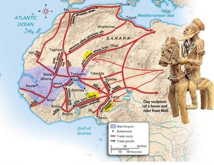
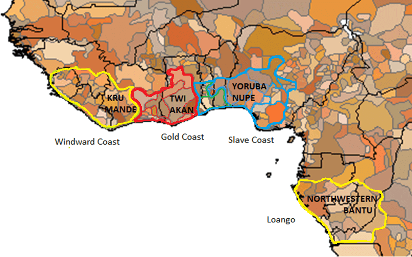
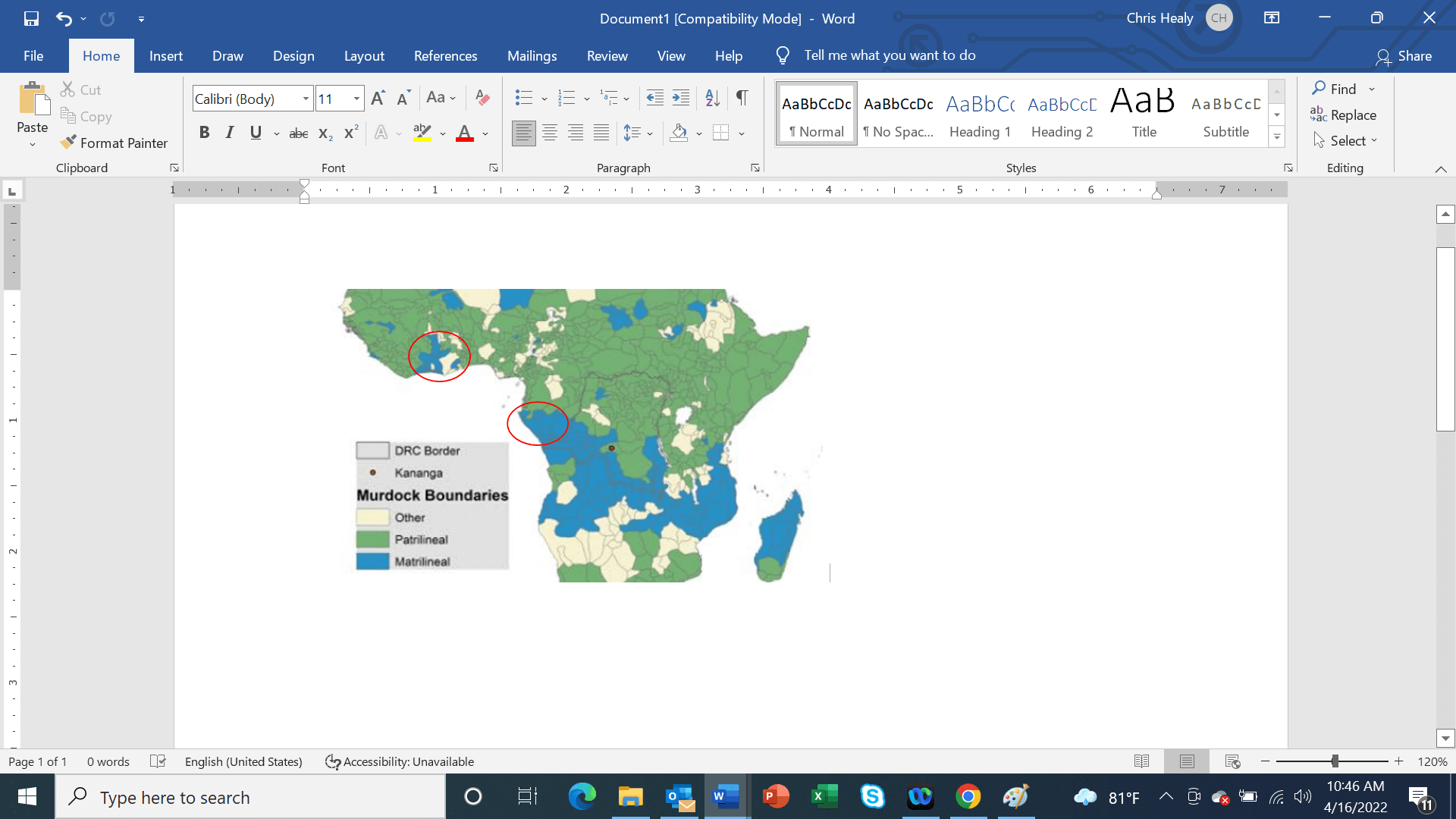 All six Maroon societies that eventually formed in the interior of Suriname were matrilineal, essentially because the largest number of Africans who came to Suriname originated in matrilineal belt (see map to the left), especially on the Gold Coast (Akan, Twi speakers) and Ivory Coast (Baule), as well as on the Loango region between the Zaire River and Cape Lopez in Gabon (North Wester Bantu culture area). Thus, most of the African nations where the Maroon originated from were also matrilineal. Matrilineality is the tracing of kinship through the female line. It may also correlate with a social system in which each person is identified with their matriline – their mother’s lineage – which involves the inheritance and use of clan and lineage property, and the acquisition of political titles in the community as well as the higher-ranking political functions in Maroon society.[i]
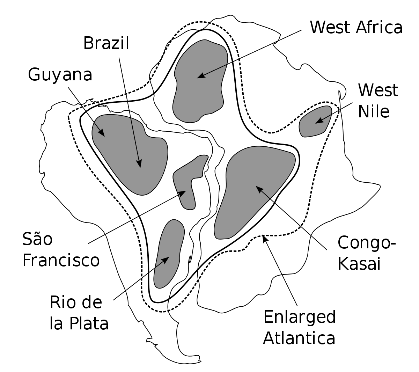 Finally, we can’t help noting that prior to the arrival of Twi speaking Akan Africans in Suriname, with extensive experience on gold mining, efforts to find gold in the interior of Suriname failed. As soon as the influx of slaves from the “Gold Coast” increased significantly, gold was found in Suriname. What a coincidence. This is not surprising; geologists know that the mineralization patters on the Gold Coast and in the interior of Suriname have a shared history. When the first gold deposits were formed in Suriname some two billion years ago, Africa and South America shared the same continent – Atlantica.[i]
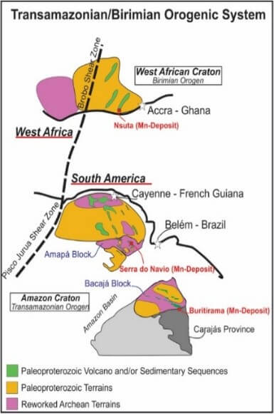 While visiting Kumasi and the nearby Obuasi gold mine, I was struck by the striking similarity of the landscapes.[i] The lateritic and saprolite soils in the Kumasi region reminded me of the natural environment and earth in Brokopondo District in Suriname, where extensive gold mining takes place.
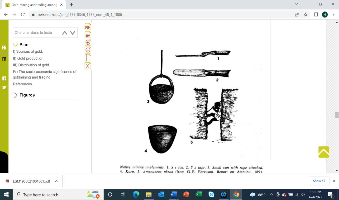 As unexpected as it may seem, young villagers from Nieuw Koffiekamp without mechanized mining equipment, resorted to the medieval gold mining methods of the Ghana, Mali and Songhai empires.[xxvii] During the 1990s, miners dug vertical shafts into the ground, some ten to twenty meters deep. They used ladders to descend into the pit to recovered the mineralized ore. Instead of using a bowl tried to a rope, the ore was placed in rice bags and carried up the ladders and out of the shaft. The ore was panned in a small lake at the foot of Royal Hill.